
Having explored other difficult but rewarding long hikes in Baxter State Park, I decided to finally try a challenging early fall hike of Mount Coe (3,760 ft), South Brother (3,963 ft), and North Brother (4,052 ft), a 10.1 mi loop (extendable to about 12.5 mi if you include Fort Mountain in the spur hike from North Brother). This exhilarating trek begins with its most difficult ascent first, and hits peaks (including a 4,000 footer) that allow for views on a clear day in all directions of Baxter State Park and its surroundings. I started this hike based upon a route recommended by the book Hiking Maine’s Baxter State Park, a relatively new volume which I have dog-eared, bookmarked, and annotated in pen/pencil. As recommended in that book, every other guidebook, and the Baxter State Park ranger I consulted, I took the loop counterclockwise, in order to tackle the Mount Coe slides uphill, rather than trying to descend (more on that later). To navigate, you can use the free downloadable Kidney-Daicey map from Baxter State Park, or the more durable (my choice) Map Adventures’ Katahdin Baxter State Park Waterproof Trail Map.

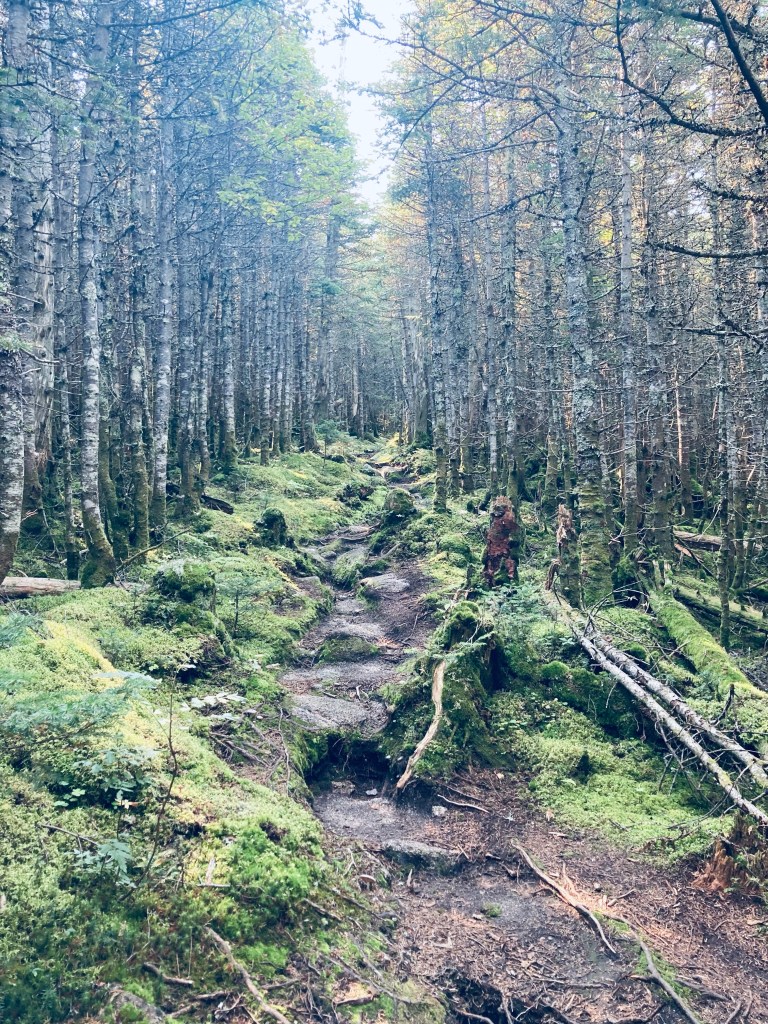
The parking area for Mount Coe and the Brothers is on the Park Tote Road just south of Slide Dam picnic area, on the east side of the road. I took a long, quiet morning drive south from South Branch Campground, with the windows down to breathe in the foggy morning dew and listen for about an hour. No moose crossed in front of me, but I saw several ruffed grouse scurrying into the undergrowth lining the Tote Road. At the parking lot, across from Nesowadnehunk Stream, a large hiking group was meeting and beginning to pack up breakfast and coffee in preparation for a hike in smaller pairs and trios. The hike started easily enough on a relatively flat grade, with the trail going across a couple low streambeds. The temperature began to increase as I climbed up and out of the valley, ascending a narrow staircase with the pretty runoff of the stream to my left. At about 1.2 miles, I reached the intersection of the Marston and Mount Coe trails and turned right towards Mount Coe. Almost immediately, I started seeing moose droppings. The trail was flat and mossy, almost downhill at the beginning, with quiet, green Eden-like surroundings of mossy hummocks and clear, cascading brooks.
I had arrived at the trailhead about an hour after sunrise, but the sun had still not summited the peaks to the east, so when it did, at around 8 AM, it peered over like a death ray. So, when the trail crisscrossed the cool stream and moved uphill, I missed the air conditioning that the cold running water had provided. Here, I passed a friendly group of three on my way to the final ascent of Mount Coe, then another, even more amiable group of three making their way up the slick, steep slides. It’s difficult to find grumpy people at Baxter State Park. Back to the slides – they were as advertised, difficult, slick with morning dew and runoff, and sharp (I left some blood there on a handhold). I had planned to only use my hiking poles, collapsed and stowed on my pack, on the descent, but thought twice about that plan while navigating the steep, slippery surface. I can’t imagine the difficulty of climbing down this stretch on coltish, tired legs on a clockwise hike. Thankfully, the slide gave way to a thin path through thin spruce with roots and trees for handholds, leading to the Mount Coe summit, with unbelievable views in all directions.
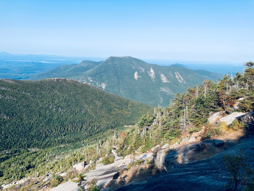
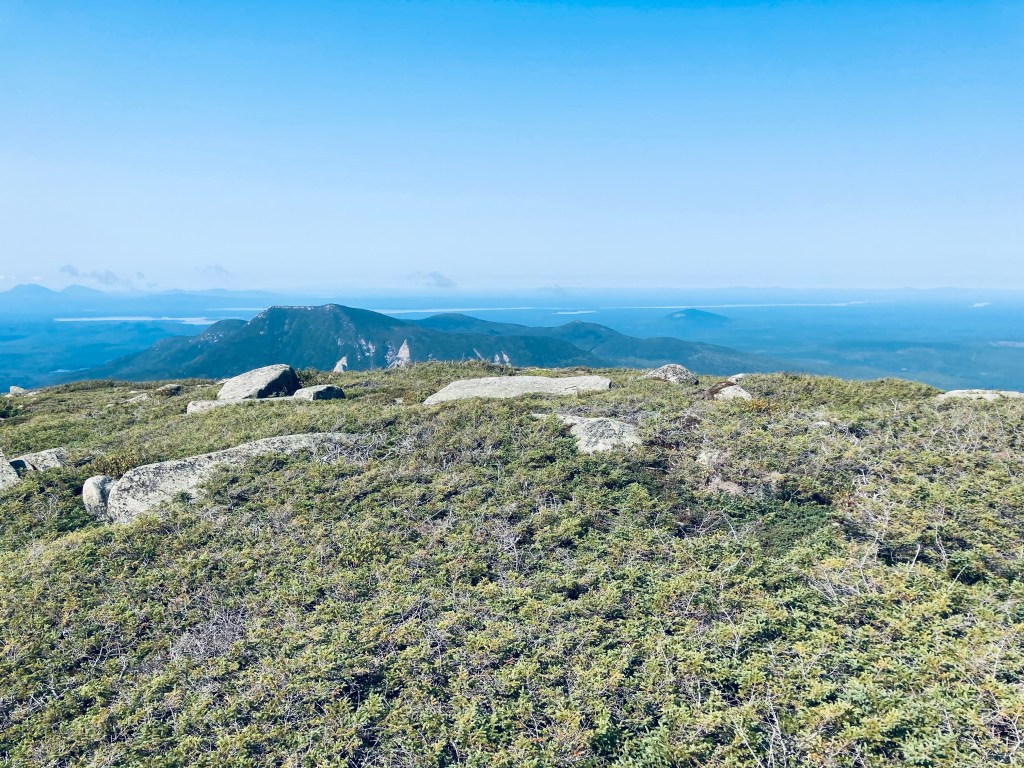
This difficult climb turned into a peaceful, shaded ridge hike with the sound of the higher elevation winds, and periodic views of Doubletop through the thin trees. At about 3.9 miles, I turned right to head up a mossy, tree-lined climb to the summit of South Brother (.3 miles each way). To my delighted surprise, there were fat, dewy, wild blueberries still available on the sides of the trail, which was a mix of rocks and roots, in the scramble to the summit. Here, after the scrub pines, there were 360-degree views of the Klondike, Katahdin, the Traveler formation, and over Doubletop all the way to the Allagash.
I took the time to send a proof-of-life text to my wife and daughter and take off my boots and socks and let them air out, while I enjoyed the sunny morning. I scrambled back down, using my hiking poles, turning right on the trail towards North Brother, seeing two more hikers ascending together. The trail from South Brother to North Brother is fast and flat, even having a sand and gravel surface in places. Hiking Maine’s Baxter State Park recommended not climbing more than two peaks at a time due to difficulty, but feeling good, I continued north at the intersection with the Marston Trail to North Brother’s summit, to complete the trio.
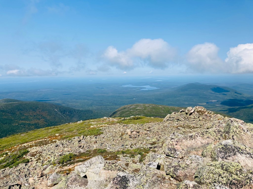
The section of the Marston Trail leading towards the peak began the same way as the last flat stretch of the Mount Coe Trail, even heading disconcertingly downhill, which always imports a feeling of dread when you know you think you are losing ground while climbing a 4000-footer (even I can do that elevation math). But the .8 mile trail slowly turned rockier and steeper, then became an upward slog and series of switchbacks. I saw a couple descending, and greeted them, then reached the peak of North Brother still energized by the sun and the effort, another 360-degree view of Baxter, and of Katahdin. I paused to use my JetBoil to cook up a freeze-dried Chili Mac meal and stow it in my pack for later. The trail down was nice and easy, with periodic views to the left from the Marston Trail overlooking Teardrop Pond and Doubletop.

One of the best parts of long mountain hikes is seeing from substantially higher or lower elevation the destination ahead, and thinking, disconcertingly, that there is no way you are getting there, then improbably reaching it after putting one foot in front of the other. The Mount Coe and Brothers loop is such a route, with sufficient elevation disparity and the ability to view distant waypoints from the slog of the hike, then hit them unerringly. A long series of switchbacks and downward steps took me to Teardrop Pond, at about 8.1 miles, a quiet and solitary place patrolled dutifully by a belted kingfisher. Here I stretched out on a warm rock and enjoyed the chili Mac meal I had cooked on the top of North Brother. After a break, the long descent continued, until reaching the familiar intersection with the Mount Coe Trail, where I turned right to complete the loop and head back to the parking area.

(Disclaimer: This post contains affiliate links, and as an Amazon Associate Hiking in Maine blog earns from qualifying purchases.)
