We recently tested a Venustas Heated Vest, which has become a Fall staple. In the Maine mornings and evenings beginning in September, there is a chill in the air (even in my house!). Because I tend to be a cold person, any extra heat I can get, I will take it. The Venustas Heated Vest has six heating elements to generate warmth in the left & right shoulders, mid-back, left & right pockets, and collar. There are three settings indicated by an illuminated LED around a button on the chest– high (red), white (medium) and blue (low). Generally, when I go for heat, I go all-in, which means I usually have it on the hottest setting. The battery lasts about three hours in this mode. I can turn it down to medium or low if I am wearing it to rake leaves or hike or do something which gets my body heat up. Venustas advertises five to six hours of use on medium level, eight to ten hours on low setting. If I’m just going for my slow morning walk, I keep it at high.
Venustas Heated Vest, Women’s M
My favorite part about this vest is the heat on my neck – it reminds me of when I get a shirt out of the dryer and put it on – so cozy. I think as the winter sets in here in Maine, I will be pairing this with a parka on top of it because I will need extra warmth in my arms. However, for September, October and November I will be wearing this with a long-sleeve shirt and maybe a thin fleece. You will never get the sense that this vest will burn you. Even at the highest setting, it is not too hot. It is very easy to use – push the button for three seconds, it turns on. Push it again, it turns the temperature down. Push and hold for three seconds and it will turn off. When the light goes off on your vest, the battery will need to be recharged, which takes 6-7 hours.
Venustas Heated Vest, Women’s M
I’m happy with the Venustas vest and my only critique besides the long recharge time is that I don’t care for the company name written on it so prominently (because I don’t like writing on clothes). Overall, though, I’m loving this heat!! The 100% nylon vest water and wind-resistant exterior is machine-washable (minus the battery, obviously), and comes with a one-year warranty on the battery and two years on the heating elements.
(Check the website of the Prouts Neck Association for updates, as the Cliff Walk is currently closed. January 2024 storm damage resulting in pending repairs of up to $4 million, which won’t be complete until possibly 2025, according to a May 2024 Portland Press Herald article.)
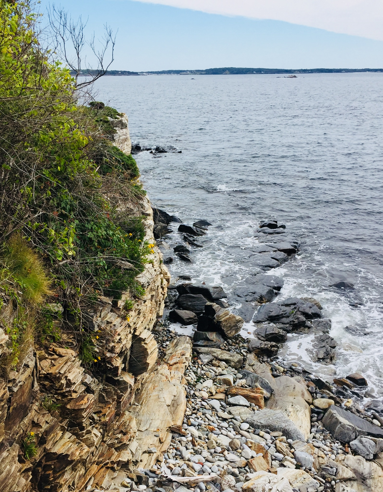
If you like dramatic cliffs, ocean views, rocky beaches and stunning homes, this may be your walk! The residents at Prouts Neck in Scarborough, Maine harbor a secret gem in their gated community – but fret not – while the entrances are hidden and parking is complicated, it is still possible (and legal) to walk variations of the same 1-mile route that Winslow Homer did, even if you are not an “insider.”
This is definitely categorized as a Sunday stroll-type of walk, a walk with a good friend that you haven’t seen in a while or a lone walk with a camera or sketch book. The uneven terrain and sometimes narrow path demand a leisurely pace. The smell of rugosa roses, the salty ocean breeze and the lobster boats are center stage and require frequent pauses. The views are unbeatable. The only problem is logistics. Below we will describe how to safely and lawfully enjoy a hike in summer, or even winter, from the Black Point Inn (45 minutes to an hour) or a longer “lollipop” loop from Ferry Beach (3.7 miles, about an hour and a half).
Western Cove from Black Point Road, Prouts Neck, Scarborough, MaineContinue reading →
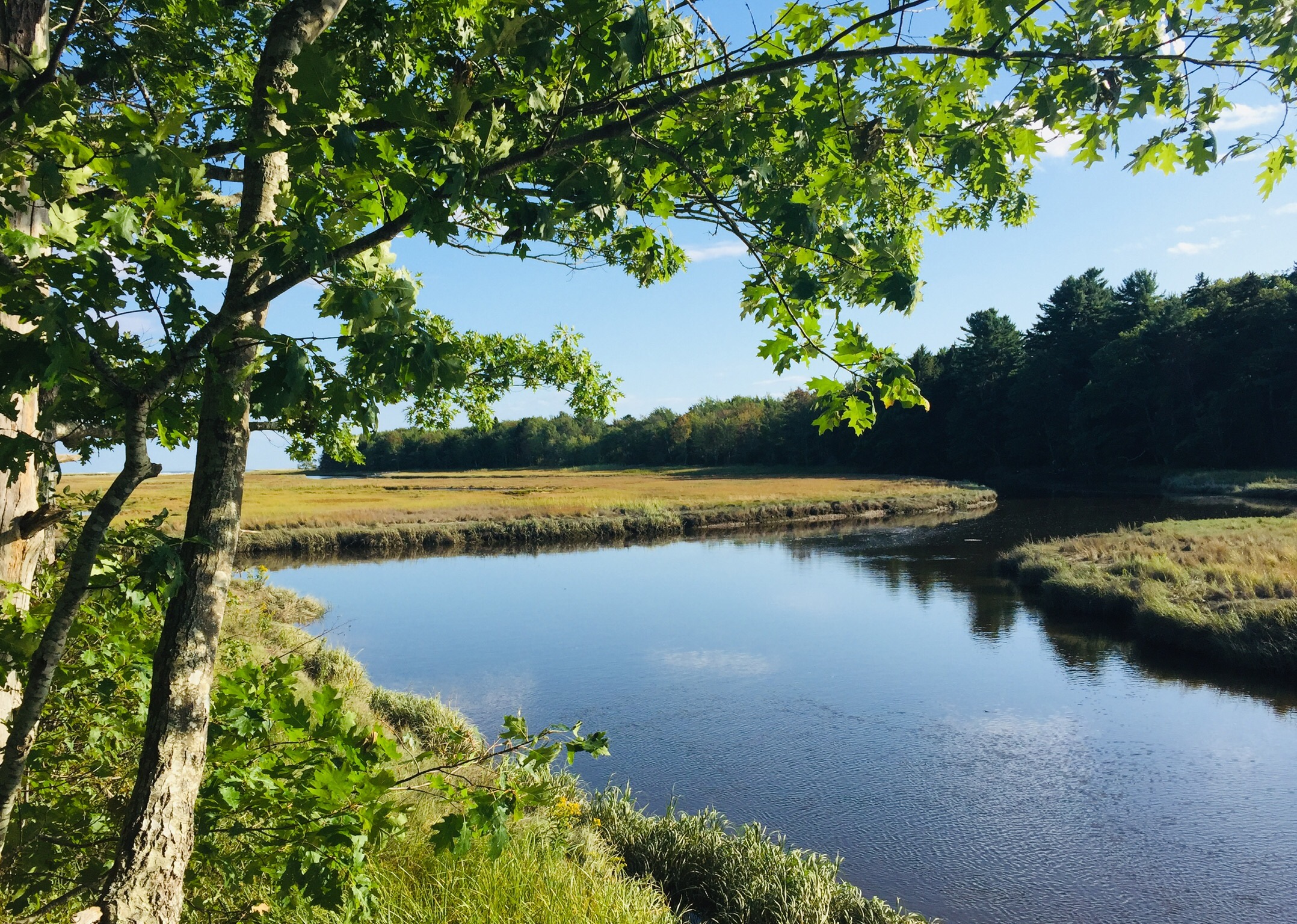
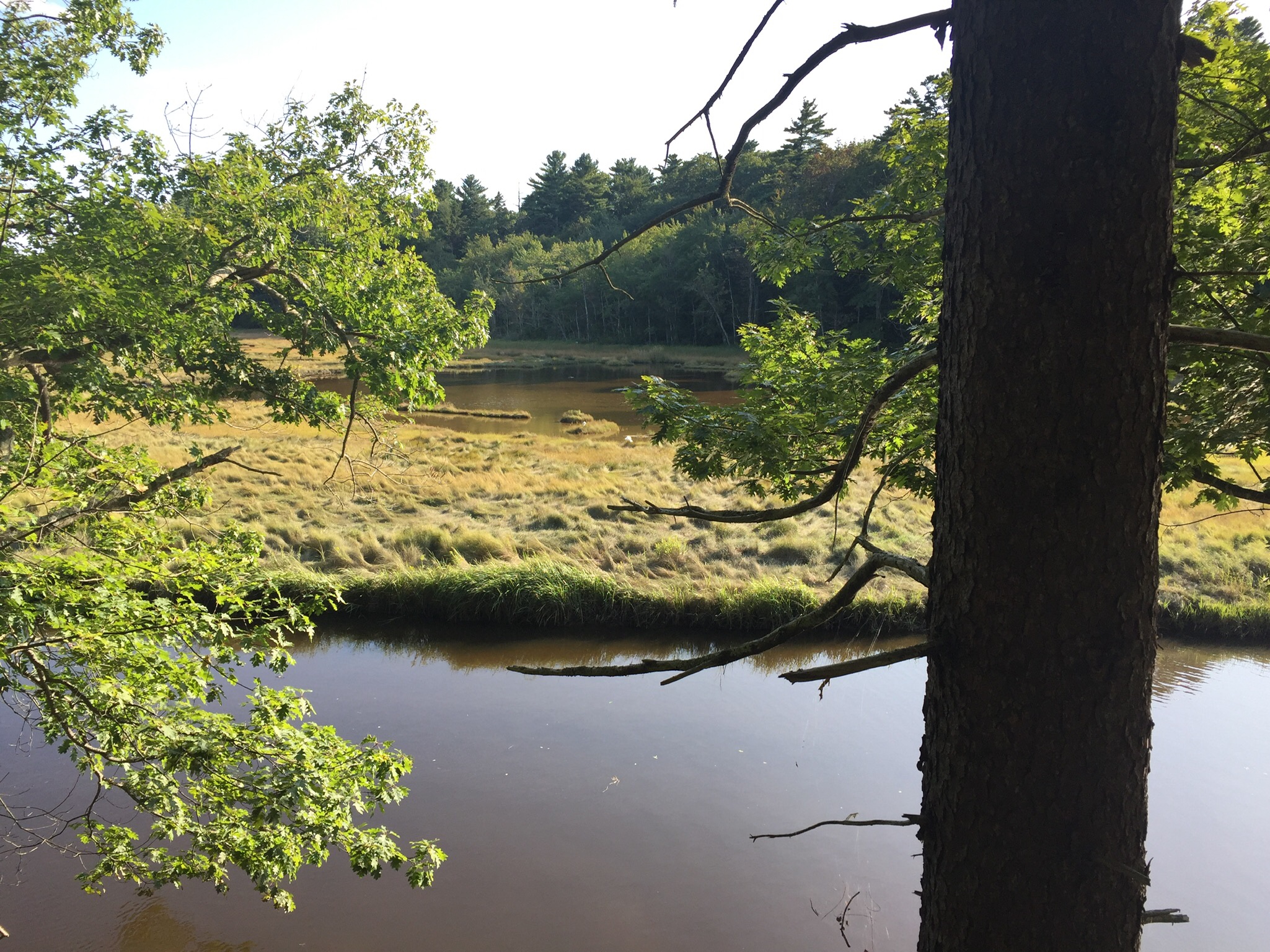
Salt marsh view on the Carson Trail, Rachel Carson National Wildlife Refuge, in Wells, ME.
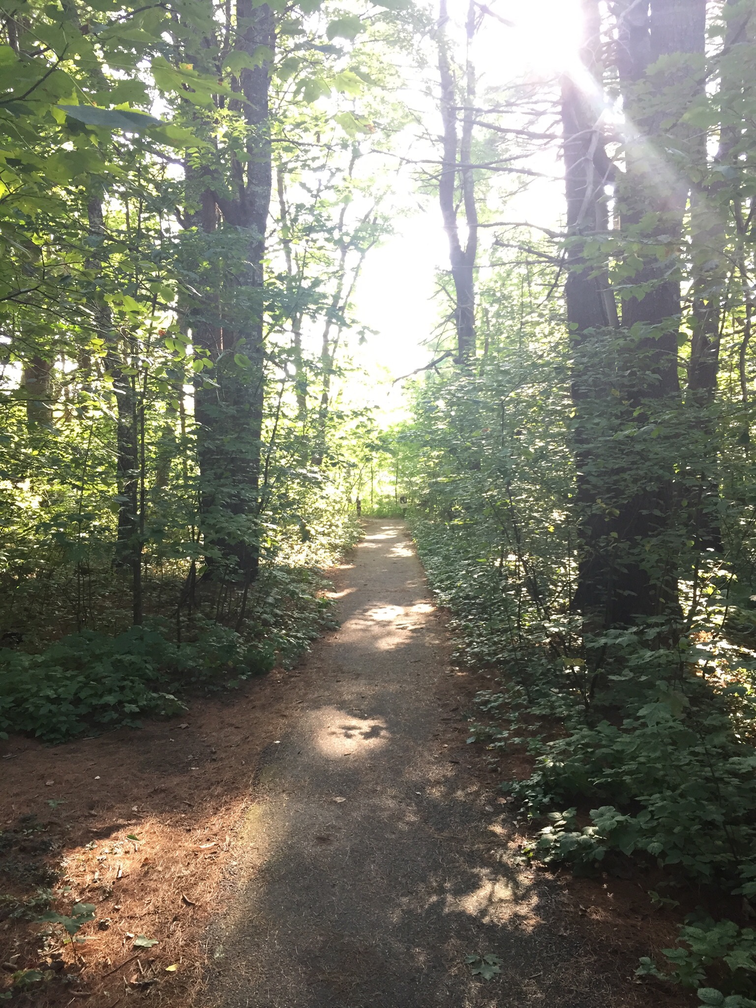
Established in 1966, Rachel Carson National Wildlife Refuge is located along fifty miles of southern Maine coastline and divided into eleven sections between Kittery and Cape Elizabeth. In the Wells section, the Carson Trail is a short, easy, beautiful stroll that is flat, wide enough for two people side-by-side, and well-suited for those who don’t want elevation or rocky paths. This one-mile loop showcases coastal wetlands, consisting of salt marsh and deciduous and pine forests. Since I was already in the area, it seemed like a perfectly laid-back 45-minute activity.
The wide, flat, well-marked Carson Trail, Rachel Carson National Wildlife Refuge, in Wells, ME.
The refuge, managed by the U.S. Fish and Wildlife Service, has its entrance at 321 Port Road in Wells, Maine, with parking, restrooms, picnic tables, signage and maps, and is open from sunrise to sunset. I would recommend getting the trail guide (found in a box at the trailhead) not because there is any danger of getting lost (near impossible) but because it details 11 stopping points along the trail. It explains various elements like “critical edge,” the difference between salt hay and smooth cordgrass, and a brief history of Rachel Carson. (If you can keep your map in good condition, please return it to the box at the end). The trail was relatively quiet, which was surprising for this beautiful Saturday afternoon.
Trail kiosk with guide/map, Carson Trail, Rachel Carson National Wildlife Refuge, in Wells, ME.
The trail follows Merriland River (on your right) and then halfway through (viewpoint #6), you will see the intersection of Merriland River and Branch Brook as it forms Little River. At several of the lookout points, you can see the ocean crashing in the distance or sit on a bench and watch a white heron in the tall grass. Everything is well-maintained and safe. I would highly recommend this walk for small children, who can look for birds, watch as the tide comes in or goes out or run ahead of the adults to get to the next trail marker. Leashed pets are allowed (on the Carson Trail only). I would emphasize staying on the trail for obvious reasons but especially because I noticed poison ivy on the trail edge.
Salt marsh view, Carson Trail, Rachel Carson National Wildlife Refuge, in Wells, ME.
As a bonus – it is only a five-minute drive from the Wells Reserve at Laudholm, which has 7 miles of trails, and so you could make your way over there with a picnic lunch and enjoy the rest of the afternoon.
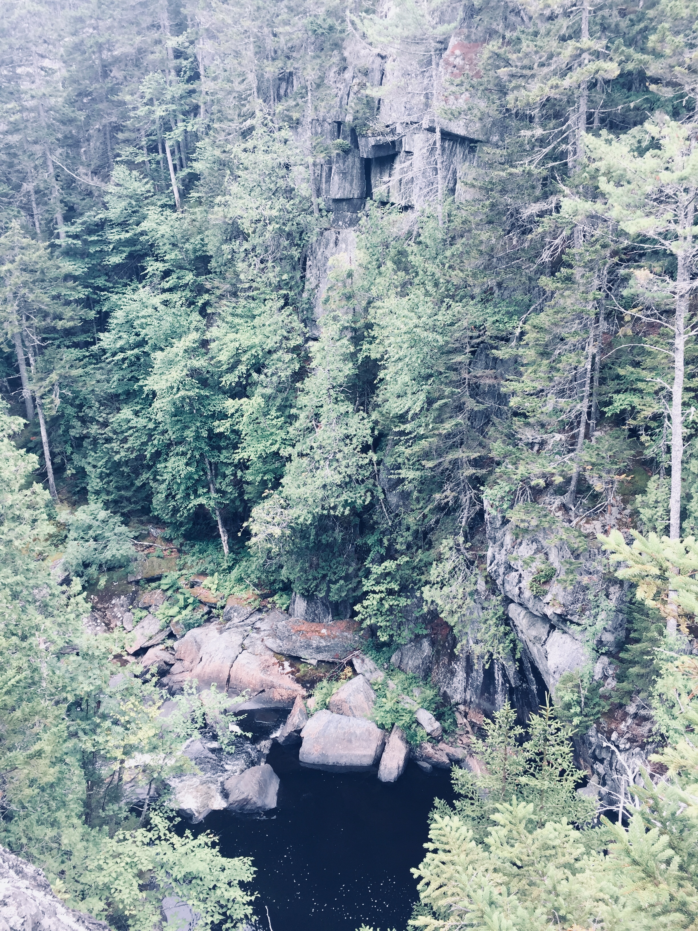
Gulf Hagas, a gem hidden in the 100 Mile Wilderness of Maine’s Appalachian Trail, has been dubbed the “Grand Canyon of the East.” Recently, this moderate (in difficulty, not grandeur) hike along the West Branch of the Pleasant River is getting more press, for better or worse, including mentions in Outside Online’s Best Hike In Every State, and in the Sep/Oct 2019 Outside Magazine print edition. Why? Waterfalls! Appalachian Trail! Beautiful rock formations! Swimming holes! Moose (well, moose droppings, anyway)! This is what you can tell any curmudgeons (I won’t name names) who come bearing excuses like, “too many bugs” or “that sounds like a lot of walking” or “I don’t have hiking boots.”
Gulf Hagas is located near the small town of Brownville, ME, about 3.3 hours from Portland and accessible through the gatehouse at Katahdin Iron Works Road (and two other checkpoints). The Katahdin Iron Works (KI) Jo-Mary Multiple Use Management Area is a region of about 175,000 acres of privately owned commercial forest, wedged conveniently between Moosehead Lake and Baxter State Park. All visitors – even those who are not camping – must stop at the gatehouse to pay the day use fee (and the camping fee if you are camping). They accept cash or check – and more cash than you might expect. On our recent camping and hiking weekend to celebrate the end of summer, four adults and one child camping for two nights and hiking for two days was $176 (under 18 is free). Information on fees can be found at North Maine Woods site. Also, pay attention while you are driving on those roads- the pot holes will get ya.
The gatekeeper at KI gate was friendly and helpful and happy to answer my questions about swimming holes and the state of the privy/outhouse at the campsite (brand new). I regret not asking him about a good spot to see a moose because I got the sense he would have known. The maps available at the gate (or print in advance here) of the area and of Gulf Hagas are particularly useful.
A small poplar grows at the top of the remaining Katahdin Iron Works furnace by the KI Gate.
I would recommend camping at the KI/Jo Mary campsites. Unless you are one of the few people that live nearby, you are going to want to relax somewhere after you hike for several hours. We lucked out and got one of those late summer weekends where the evenings require jackets, the campfire is crowded and the days warm up enough to be in shorts. Late August in Maine!
Our camping site (Pleasant River #1) was sandwiched between a clean, quiet, shallow river and a dusty road that had about 4-5 cars per hour go by during the day. It included a new outhouse which (no joke) smelled like fresh pine when we arrived. The site had enough privacy and except for a few barks from a dog at a nearby camp site, we did not hear the neighbors. The covered picnic table was perfect for providing shade.
Pleasant River Campsites managed by KI Jo-Mary, Inc., near Gulf Hagas
I was practicing the art of low-maintenance and so decided this would be the trip that I would go without a pillow. I spent the first night with my head on a hard-sided duffel bag, cursing this decision. Alas, nobody will ever say about me that “all she needed was a small patch of land to lay her weary head.” Turns out I need a blow-up mattress and a pillow. And chocolate. And delicious “camping-easy” coffee that even has some health benefits. It is a splurge, but when you are camping without a pillow, you will want that coffee.
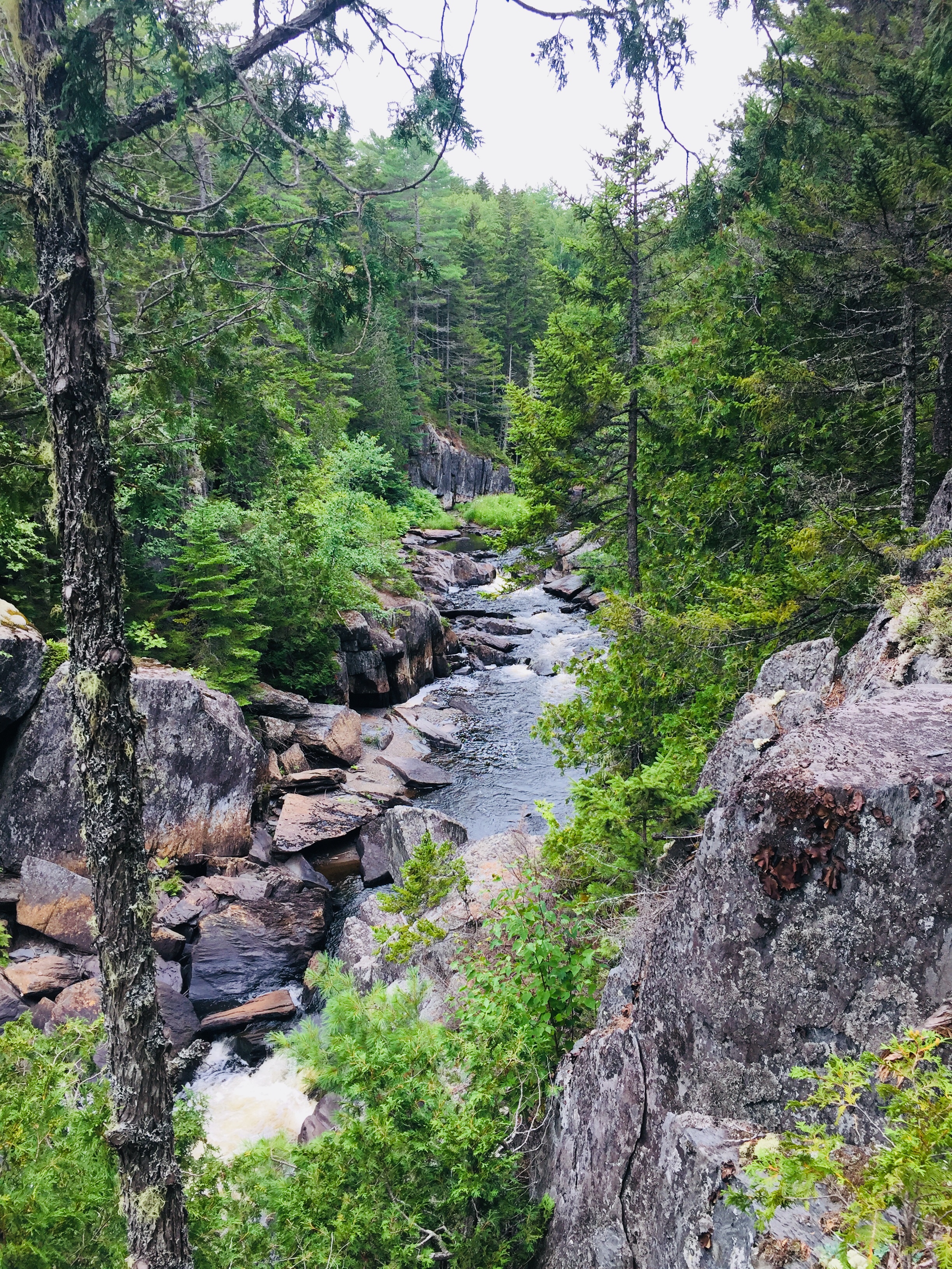
We set up three tents in the three nooks of the large site, which had a great mix of sun and shade and was approximately 3.5 miles from the trailhead. My sole complaint was the road. Given the ruggedness of the road, the dust and the clouds of marijuana smoke billowing from passing cars, my advice would be to drive to the trailhead as opposed to walk. Save your energy for the gorgeous scenery along the Gulf Hagas Rim Trail! This is the hike with all the oohs and ahhs.
The trailhead for the Gulf Hagas Rim Trail is well-marked and on this sunny August Saturday the parking lot was overflowing. Several wooden hiking sticks rested next to the large trail map, to borrow for fording the river which comes at approximately .2 miles into the walk. Fortunately, the river was shallow and only reached mid-calf in the deepest areas. Because of the slippery rocks, I would highly recommend a walking stick or hiking poles and water shoes – my daughter crossed in bare feet but it did not look pleasant. The depth of the water varies from season to season and in dangerous conditions, there are other ways to hike the trail without crossing the river.
Crossing W. Branch of Pleasant River on AT on way to Rim Trail, Gulf Hagas
After the river crossing, you are on the Appalachian Trail. I was impressed with all those hikers who had walked perhaps since Georgia. Follow those white blazes, through The Hermitage (lots of huge, old white pine trees and hemlocks) and continue to the Rim Trail, where you say goodbye to the folks who are walking the 100-Mile Wilderness of the AT and you follow the blue blazes instead.
We took the Rim Trail along the water and then returned along the Pleasant River Tote Trail. See map here. In total, with all the small side trails to viewpoints, it is about 9 miles and there is an option to make a smaller loop, if you take the Appalachian Trail cutoff. Alternately, Gulf Hagas can be reached from a parking area for the Head of the Gulf Trail (opposite end from the AT), closer to the Greenville Road.
Many families with small children appeared to turn around at Screw Auger Falls or Buttermilk Falls. Several people were jumping into the water at Screw Auger Falls and it was the busiest spot along the walk. Everyone in our party seemed to be allergic to big groups of people (Husband mumbled something about Disneyland) and so we moved along. Certainly on a hot day this would be a great spot to cool off and I can’t imagine a more picturesque spot.
The hike does not include significant elevation and it is well marked. There are some little scrambles over rocks that a well-placed hiking pole or a tree branch would help with, but otherwise it is what I would call moderate. The AMC Maine Mountain Guide suggested allowing 4 hrs and 25 minutes for the loop, which is reasonable. We took plenty of breaks to relax and snack, and completed it in about 6 hours.
The trail has plenty of quiet, scenic areas to stop and sit and rest and stick your feet in the water while eating a peanut butter and jelly sandwich. My group had a couple of stoves and made sophisticated camping meals and hot tea. Daughter is a huge fan of Mountain House Chili Mac while the breakfast favorite was the Peak Refuel Breakfast Skillet. The JetBoil camping stove continues to impress in its efficiency.
We took the Pleasant River Tote Trail back and it was scenic in its own right – meandering woodland paths – quiet, green and easy. The walk back was much faster than the hike along the Rim Trail and the river crossing that you complete again to get back to the parking lot was refreshing on tired feet.
For post-hike refreshment, we enjoyed the cool river by the campsite, grilled hamburgers and beer and wine, and watching kingfishers and small, fast-moving ducks move by. But if you are headed back towards Portland, consider stopping at Bissell Brothers Brewing Three Rivers on Elm Street in Milo (turn right at Dot Rd just before the red train car). According to the cheery bartender, their double IPA, Preserve and Protect, is a tribute to the brothers’ father, Jensen Bissell, who was the Director of Baxter State Park for thirty years. A Katahdin benchmark is imprinted in the bar, as well. Please stop by soon, though, as an open letter on their site advises that the Bissell location, open since July 2018, will close at the end of summer 2024.
Katahdin benchmark in the bar at Bissell Brothers Three Rivers in Milo, ME
The now-famous Bissell Brothers beers are all available on tap, and delicious food is also available for purchase outside. Relax on the outdoor patio, and watch or play cornhole and ping-pong – all without the bustle at their Portland location. And continuing towards the turnpike in Dover-Foxcroft is Butterfields Ice Cream, serving up unbelievable ice cream flavors (and now, burgers, fries, and lobster rolls) since 1950.
Gulf Hagas is a memorable day-hike with friends and family, customizable to each person’s individual abilities, with memorable scenery unique to Maine’s 100-Mile Wilderness.