100 Mile Wilderness, Day 3 (Long Pond Stream Lean-To to West Chairback Pond)

010d5eb451660aa1f0ae6a5904f06f06adc2de841f
(Note: this is part three of a multi-part series on the summer 2017 attempt at the 100 Mile Wilderness by dad, 40, and daughter, 11)
Our third day, July 2, 2017, we got an early start, even though all our clothes and socks were wet, and the area around the tent was a mud pit.  The morning light revealed tents around us, almost on top of each other, as people had crowded in the Long Pond Lean-To site to escape the strong thunderstorms overnight.  We enjoyed wonderful views on the way up Barren Mountain, as well as birdsongs we had been hearing throughout from a warbler, whose music we would hear throughout the hike whenever we got to higher elevations.  We also saw small finch-like birds with dark heads near the summits, but could not figure out if they were the singers.
016cf0a26b600d52fb59b15add6ebfebb547554cf3
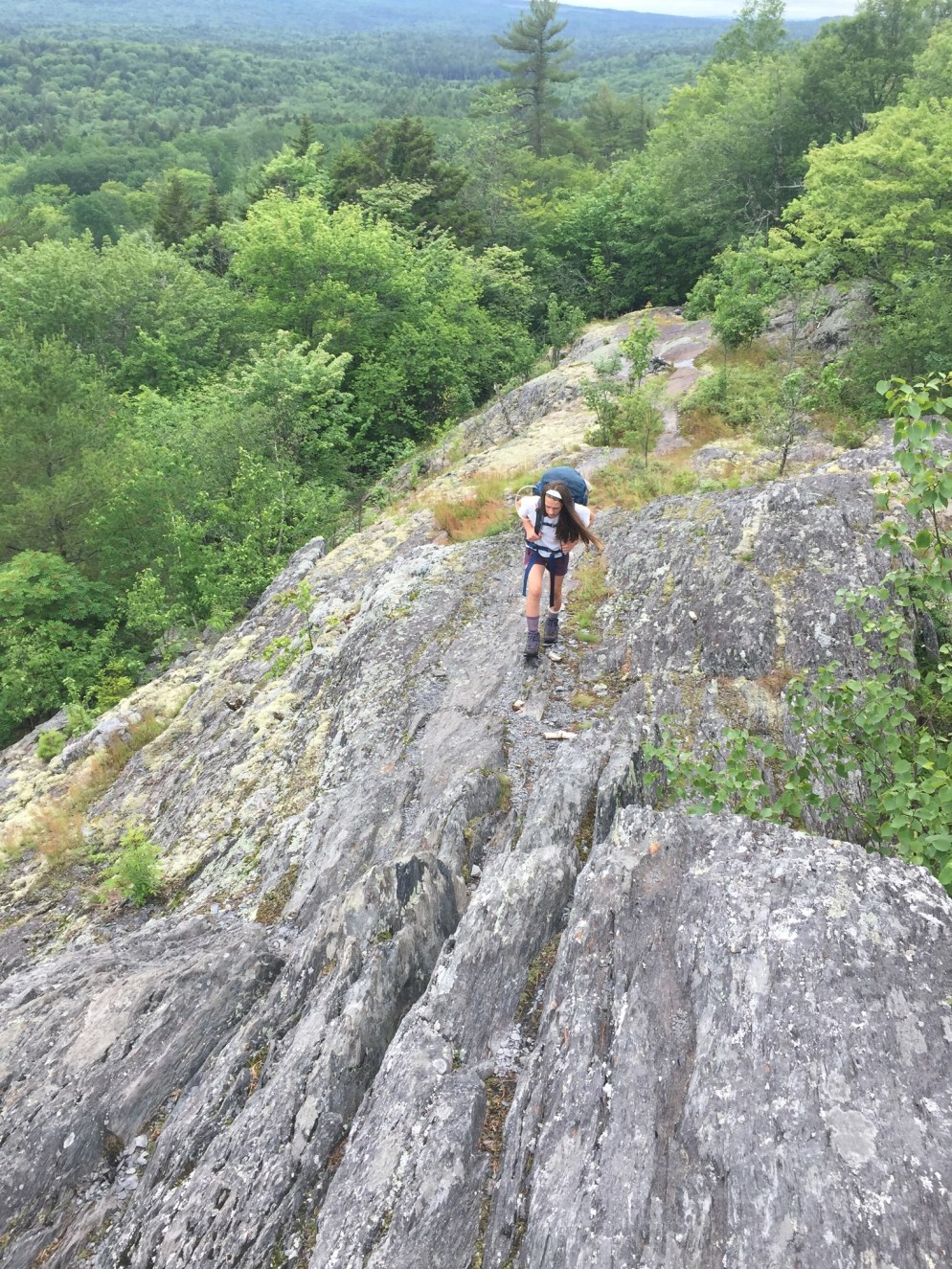
The light was particularly beautiful in the morning, and dad captured a good shot of daughter walking through the rays of sun during the ascent of Barren.  The temperature rose quickly.  We broke into our dark chocolate trail mix for the first time at the Barren Mountain Ledges, and found that this was one of the few food items of which we did not get tired.
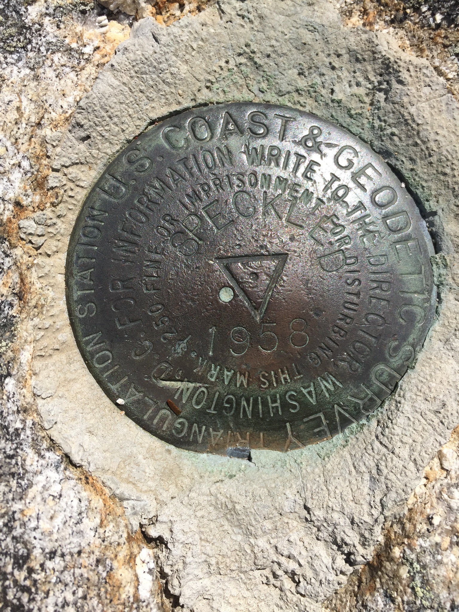
We had a tough time with some of the map landmarks, and were briefly discouraged until we were suddenly on the peak of Barren Mountain, next to an abandoned fire tower.  We met another hiker there with his elderly father, who had hurt his ankle, and they were debating their options.  It was a very wet hike, and every hiker coming southbound seemed to make a comment about the wet, boggy conditions.
 015f4407ac349d8ef313d50c4d84fca9d74f28b13f
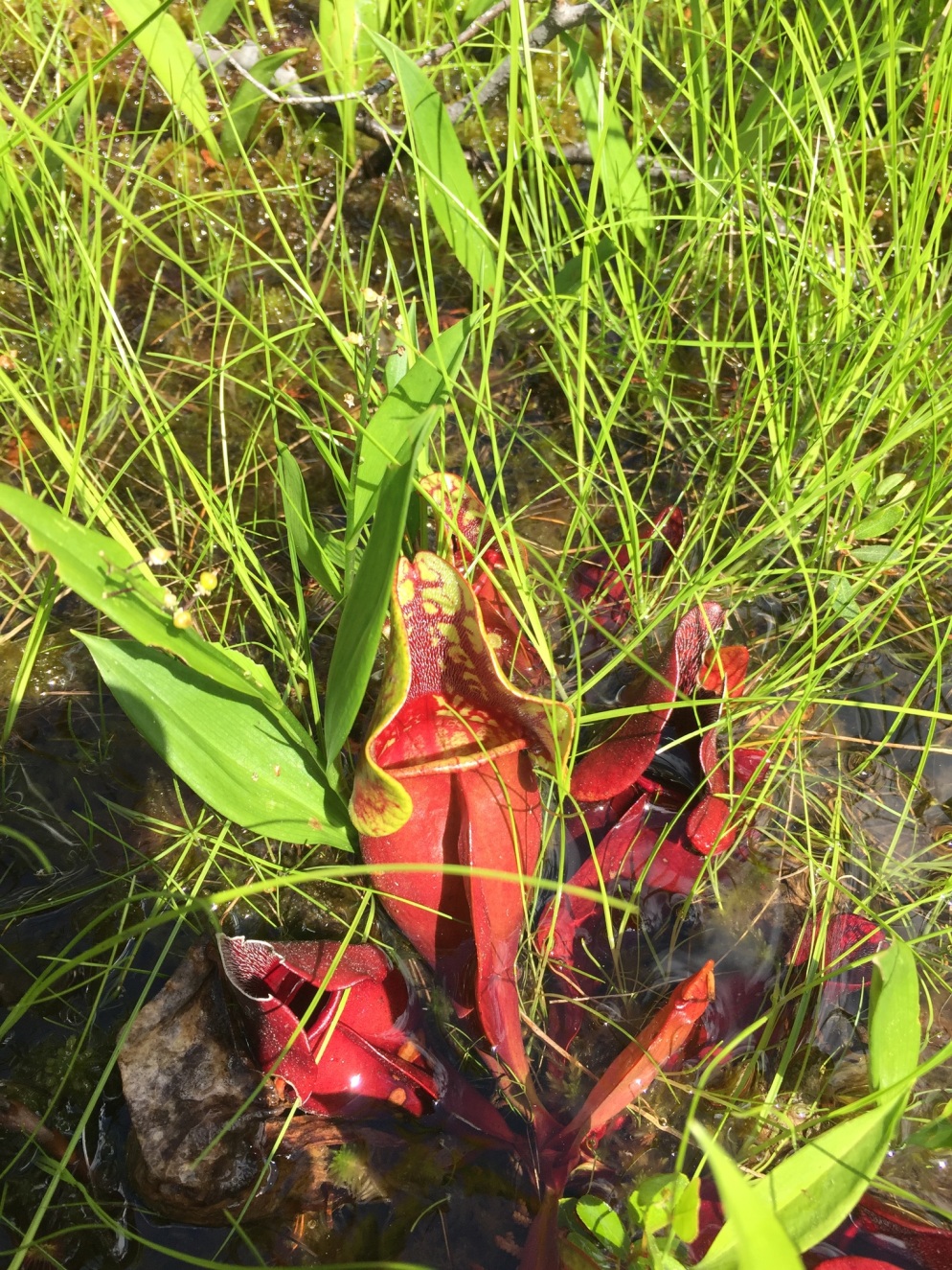
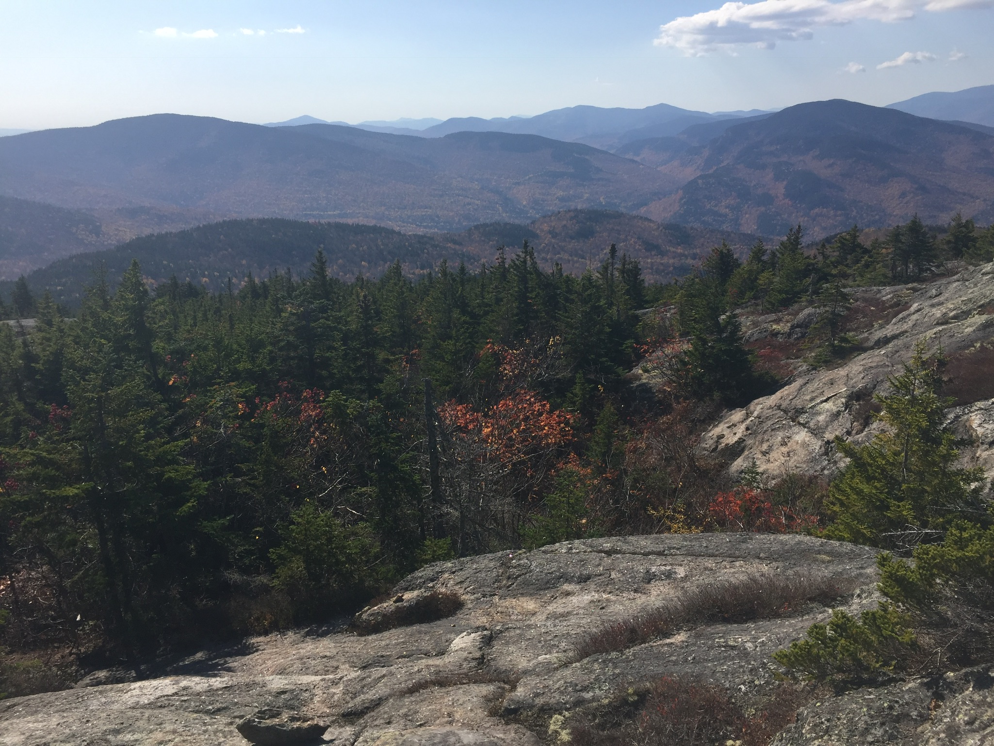
Fourth Mountain had a bog with insectivorous pitcher plants, something we had not seen, so we took photos of those.  Third Mountain had great views, but, seemingly, many consecutive summits, and we were ecstatic when we reached the side trail to West Chairback Pond.  We had done 9.2 miles over the Barren-Chairback Range, and another .2 to the beautiful campsite overlooking the pond, which we discovered was, unfortunately, teeming with aggressive leeches.
 013b1e0b8d4f264630353de23710b63192c900e6cc
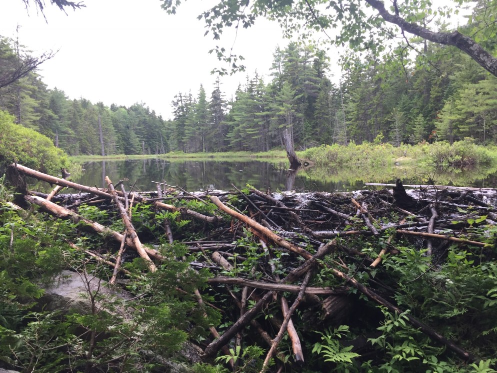
The shore contained several boats and canoes, and we wondered how (other than via the Appalachian Trail) people got in to use these.
We made a small campfire to boost morale, dry some of our equipment, and keep away the worst of the mosquitoes.  Despite (or maybe because of) the large number of fallen trees around, dad had a rough time finding a suitable spot to hang the bear bag.  With no other campers around and the strong smell of food, this was a priority.  Dad had Mountain House Chicken Teriyaki for dinner, and daughter had Pepper Steak.
Because the tent was still damp from the thunderstorms the night before, we left the rain fly off the tent, and were able to see the stars all night through the mesh above.

100 Mile Wilderness, Day 2 (Big Wilson Stream to Long Pond Stream Lean-To)

0161a17b9b9a64773056567b0dbfc01733f7ed3505
(Note: this is part two of a multi-part series on the summer 2017 attempt at the 100 Mile Wilderness by dad, 40, and daughter, 11)
At 5.9 miles on July 1, 2017, this was our lowest mileage day, due to the many river fords, challenging terrain, and the wet conditions.  We left our campsite and hiked to the river ford at Big Wilson Stream (we would also ford Wilber Brook and Vaughn Stream).  We heard a train behind us, well after we had crossed the Montreal, Maine, and Atlantic Railroad right-of-way.
Long Pond Stream was a harrowing crossing, as the rain had swollen the stream into a river, and the trail crossing site consisted of a threadbare rope across rapids.  Dad crossed there, and lost a flip-flop almost immediately.  Daughter crossed upstream, and we were putting our shoes back on when she couldn’t find one of her socks.  We looked back across the torrent, and saw a lone wool sock sitting there on a rock.  Dad waited while daughter crossed and brought it back, the same way she had come before.
(Here is a great post from the Hiking Life on how to ford a river.)
The hike uphill to Long Pond Stream Lean-To was strenuous, and we were both impressed by the river gorge below us on the way up.  We had agreed to alternate planning our route/stopping point each day, so we got into our first real trail argument over where we would try to make it.  Daughter was tough, and enthusiastic about trying to make it to Cloud Pond Lean-To (4 miles up Barren Mountain past Long Pond Stream Lean-To).  Due to the darkening clouds and the lateness in the day, dad proposed Long Pond Stream.
A helpful Appalachian Trail volunteer ambassador unwittingly resolved our dispute when we met her headed down the trail in the opposite direction.  She told us that there was not much good water available on the mountain peaks, and that the weather made Long Pond a better destination tonight.  We pulled into the Long Pond Stream Lean-To area shortly thereafter, greeted the people in the lean-to, and looked for a level campsite.  We found one uphill, and set up our tent just in time, as the rain began coming down hard, and many other people arrived, looking for places to pitch tents.  Dad had Chili Mac for dinner, and daughter had Chicken Teriyaki.  Thunderstorms and hard rain all night.  When daughter saw dad’s pruny, swollen feet at the end of the day, she said they looked like “a princess’s worst nightmare.”
In the same vein, the hike today was a wet slog, and the only pictures we took were of some interesting mushrooms on the side of a tree, which were surrounded by slugs.

100 Mile Wilderness, Day 1 (Monson to Thompson Brook)

100 Mile Wilderness, Day 1 (Monson to Thompson Brook)
(Note: this is part one of a multi-part series on the summer 2017 attempt at the 100 Mile Wilderness by dad, 40, and daughter, 11)
On June 30, 2017, we began our 100 Mile Wilderness attempt at the trailhead off Route 15 in Monson, dropped off by grandfather.  Our plan was for mom or grandfather to pick us up at Abol Bridge in ten days.  Before we left home in southern Maine (very early) daughter and dad each weighed our packs/ourselves, and discovered that hers was around thirty pounds, and dad’s about fifty-five.  We missed the parking lot, had to turn around, and saw a male and female cedar waxwing staring at us from the guardrail, which we took as a good sign.
Around 8 AM, grandfather took a picture of us, and we started north into the 100 Mile Wilderness after signing into the trail log.  We read the sign, which said, “THERE ARE NO PLACES TO OBTAIN SUPPLIES OR GET HELP UNTIL ABOL BRIDGE 100 MILES NORTH. DO NOT ATTEMPT THIS SECTION UNLESS YOU HAVE A MINIMUM OF 10 DAYS SUPPLIES AND ARE FULLY EQUIPPED.  THIS IS THE LONGEST WILDERNESS SECTION OF THE ENTIRE A.T. AND ITS DIFFICULTY SHOULD NOT BE UNDERESTIMATED.  GOOD HIKING! M.A.T.C.”
Shortly into the trip, dad slipped on two separate rocks, and cut the heel of his left hand and the pinkie of his right hand badly.  We agreed that hiking poles would have been helpful in the slippery conditions.
100 Mile Wilderness, Day 1 (Monson to Thompson Brook)
We traversed our first beaver dam, and we both marveled at the ingenuity of these small creatures.  At Leeman Brook Lean-To, we saw our first A.T. Shelter, and took a snack break, opening our peanut butter M&M’s.  We saw our first bear scat on the trail, as well as moose droppings everywhere, and a garter snake sunning itself on the trail.  We stopped briefly to talk to a (male) southbound thru-hiker whose trail name was “Starlight,” which daughter got a big kick out of.
Our first ford of the trip was Little Wilson Stream, which was challenging with the swift current and two heavy packs.  Dad went across, then came back for his pack, then for daughter’s pack, a sequence we repeated on all the fords that followed.
Little Wilson Falls
Little Wilson Falls.
This ford followed Little Wilson Falls (6.6 mi), an impressive 60′ waterfall where we took the obligatory “waterfall selfie” together.  There were also very attractive campsites surrounding Little Wilson Stream.
Big Wilson Cliffs
Big Wilson Cliffs.
After crossing Big Wilson Cliffs, we started looking for a good campsite, as we had a big ford coming up of Big Wilson Stream (9.7 mi), and we did not want to attempt it at the end of a long, rainy day.  We found a great spot at the intersection of Big Wilson Stream and Thompson Brook, 9.2 miles past our start, and soaked our feet in the cold water.
Camp set-up took the form it ended up taking the next several nights: we would both pitch the tent, and daughter would take care of the inside set-up/sleeping arrangements while dad hung up the bear bag and prepared our dinners.  We saw a bald eagle near our campsite, and we both had chili mac for dinner to celebrate our first day on the trail.  We started reading “A Walk in The Woods” by Bill Bryson under the light of the solar-powered lantern our friends had given us, and dad quickly learned how to edit dialog on the fly to make it child-appropriate.

Royce-Speckled Mountain Loop (WMNF and Caribou-Speckled Mountain Wilderness)

011211a948b34d25ce3f586b883020d806dce0c9df

On June 3, 2017, we tackled a challenging overnight hike to test out our tent and sleeping gear (and our leg power).  We got the idea to attempt the Royce-Speckled Mountain Loop in the White Mountain National Forest (WMNF) and the Caribou-Speckled Mountain Wilderness from the awesome SectionHiker blog.  This will be our first addition to our Links page, and this guy does an incredible job documenting hikes, gear, and everything else.  See here for details and map of the Royce-Speckled Mountain Loop from this treasure trove of hiking and backpacking information.  We loved the area, and you can check out our Caribou Mountain post for an alternate hike in the same area.

So, based upon internet research, trial and error, and sheer economics, we had settled on the Kelty Salida 2-person tent, and this was our first use of it while hiking.  This is 3 lb 14 oz, comes with a very effective rain fly, and we bought a footprint for it, as well, all of which came in handy later during our 100 Mile Wilderness attempt.  The Kelty Salida is easy to setup, cozy for two people (one big, one small), but enough space to sit up, and great for the elements.  Our packs and boots were too big to fit inside, but we managed to wedge them comfortably under the rain fly.

For sleeping bags, on recommendation from our cousin, we both got the Marmot NanoWave 55, (dad in a long, and daughter in a regular length).  These are insanely comfortable and packable, and we both enjoyed them.

Our sleeping pads were the Therm-a-Rest ProLite Mattress, again, comfortable and packable.  We felt they made for a good balance of being lightweight and durable, but also thick enough to keep us warm, dry, and cushioned (mostly) from the ground.

We got a late (mid-morning) start on June 3 from the parking area at the Brickett Place on ME 113, and then walked down ME 113, turning toward the Cold River Campground to the Basin Pond area to pick up the Basin Trail.  We enjoyed a break around noon at Hermit Falls.

01e8bf2b857451cee49f216c8bf6d207e06d194589

From here, it was an extremely steep climb to the Rim Junction, where we took a sharp right and picked up the Basin Rim Trail.

01f324a968791a9b600f771d483e47ae0ffe3b34ac

The ridge turned out to be a great spot to have lunch and look back over Basin Pond, and the progress we’d made.  The weather turned cold and rainy as we ascended West Royce, and the footing became very difficult, slowing our progress.

01949e317426e3245914778b8b084e3fd4d3fb2a41

We descended West Royce carefully, and the light started fading for us.  Because we were losing daylight, we called an audible, bypassing the ascent and descent of East Royce, and continued on through Evans Notch to cross over ME 113 again, and started the gradual ascent of the Spruce Trail.  We passed the no-camping boundary, and immediately began looking for a campsite off the trail, as it was closing in on 7 PM.  Daughter began the set-up of the interior of the tent, while dad prepared the makeshift bear bag with Stuff Sacks and parachute cord.  We enjoyed a well-earned hot dinner of Mountain House freeze-dried Italian style Pepper Steak, and fell asleep quickly.

010195cb96baab0bc9077bd7bee161ebd7e470326e

In the morning, we started early on the eastern side of our loop, enjoying the morning light and changing vegetation in the Caribou-Speckled Mountain Wilderness on the way up Spruce Hill, and hit the summit of Speckled Mountain around 9:30 in the morning, the view seen in the featured image at the top of this blog post.

019f3d5bbcd29f0413fd4f111a73223ac952e0f5a8

The ridge hike across the Blueberry Ridge Trail yielded wonderful views, but the constant downhill and pounding over rock was difficult on daughter’s sore feet.  The descent of Blueberry Mountain was slick and brutal, and hiking poles would have helped with balance and footing.

We stopped at Bickford Brook so that daughter could soak her feet in the icy brook.  From there it was a short walk back to our car at the Brickett Place.  We totaled about 14 miles, across some pretty rugged terrain, and enjoyed the test of our overnight equipment.

(Disclaimer: This post contains affiliate links, and as an Amazon Associate Hiking in Maine blog earns from qualifying purchases.)

Caribou Mountain (Caribou-Speckled Mountain Wilderness)

Views from Caribou Mountain

The Caribou-Speckled Mountain Wilderness area inside the White Mountain National Forest (WMNF) is an accessible but vastly underrated area to hike in Maine, and we hope it stays that way.  Uncrowded, beautiful and wild, but close enough to civilization, it is one of our favorite places.  Another option is an overnight hike of the Royce-Speckled Mountain Loop.  In October 2018, we hiked Caribou Mountain (2,850 ft) via the Caribou and Mud Brook Trails, a moderate 6.9 mile loop, which took us a bit over four hours.  The idea (and map) for this hike again came from the indispensable Maine Mountain Guide’s recommended hikes (see our review of the 11th edition here), and did not disappoint.  With fall foliage at its peak, the views were dazzling.

0179057ddd02c215a53e6f90fa4141391ba45b99e0

We again had wife/mom along as a guest, and we parked at the west trailhead on Rte 113 (Google Maps), from which both the Caribou Trail and Mud Brook Trail depart.  The temperature hovered around 70 by late morning, definitely not an October feel, and we were all in t-shirts for most of the hike.

The Caribou trail weaves over and around Morrison Brook on the way up, and we stopped briefly at Kees Falls, which was impressive, but not running at full volume due to recent drought conditions.  Shortly after the falls, we startled a comically fat raccoon, which stopped foraging, and disappeared (slowly, and with effort) up the opposite side of a tree.  A steady uphill climb brought us to the Mud Brook Trail intersection, and we turned right for the final push to the summit, where we sat in the sun and enjoyed a snack.

012082962b6fb094e6a081c48db079b2d1d8a54f1a

The views from the summit and the ledges below were incredible, highlighting the autumn colors.

Views from Caribou Mountain

Our descent was swift, and made us grateful that we had climbed via Caribou, rather then Mud Brook, which would have been more of a scramble, had we been moving uphill.  The dry leaves made for uneasy footing, however, and we could have used some hiking poles to stabilize ourselves.  The route from the summit to the treeline on Mud Brook was not well-marked, and there were some twists and turns, but we found our way.

Finished by late afternoon, we extended the outdoor day by enjoying a great meal and cold drinks at the screened-in dining area at Ebenezer’s Pub in Lovell, the perfect post-hike location.

(Disclaimer: This post contains affiliate links, and as an Amazon Associate Hiking in Maine blog earns from qualifying purchases.)

Megunticook Loop at Camden Hills State Park

Camden Harbor and West Penobscot Bay from Mount Megunticook

Midcoast hiking means dramatic ocean views.  We first explored Camden Hills State Park in April 2017, when we started our 100 Mile Wilderness Training with a relatively short (5.4 mi) and moderate 3 hour hike- the Megunticook Loop at Camden Hills State Park, via the Mt. Megunticook (10 on map), Ridge (3 on map), Slope (9 on map), and Multi-Use (11 on map) Trails.  The idea for this hike (and many others) came from the indispensable 10th edition of the Maine Mountain Guide , which we have dog-eared and highlighted, as it is an incredible wealth of knowledge (Amazon link is to the new and improved 11th edition, and you can read about all the updates here).  Parking is easy, and a small fee is charged for entrance.

Camden Hills State Park map for Mount Megunticook

It was a good opportunity to test out some of our new equipment, in unexpectedly snowy conditions – the bulk of the hike was done through deep, crusty snow and sheets of ice.

Icy stream, Mount Megunticook

In addition, we had our cousin, an experienced hiker, with us, as well as our wife/mom, a um, not-so-experienced hiker (her meal for the trail was a Ziploc bag of peapods, which she accidentally stepped on in the parking lot).

This loop had some great views along the way, particularly from Ocean Lookout, but not much to see at the top. It was a fairly easy climb, but we would recommend doing it in the late spring, summer, or fall. The trails were well-maintained and this loop had a gravel path for parts of the way. With an elevation of 1385 feet, it was a steady climb for most of the way up.

Camden Harbor and West Penobscot Bay from Mount Megunticook

This was the first time we tried our packs. For dad, an Osprey Xenith 75L pack, with an Osprey UltraLight Raincover, XL. For daughter, an Osprey Ace 50 Night Youth 50L pack (it has a built-in raincover).  We equipped each with an Osprey Hydraulics 3L reservoir, for hydration.  Obviously, we didn’t need packs or a hydration bladder of that size for this hike, but they are so well made, we chose to just fill them with less water.

We also got to try out our JetBoil stove- a freeze-dried meal of Chili Mac at the top required heating.  Due to dad’s disdain for instruction manuals, the stove spewed gas noisily for several minutes before we figured it out (dad’s fault, not the stove, which we found to be excellent).

A brief cautionary tale- we have probably undersold the difficulty of hiking in the snow present on Megunticook.  Wife/mom had issues with wet shoes/socks, and our mountaintop dining was cut short by a speedy descent.  Dad/daughter agreed that the extra time heating/mixing made the Chili Mac better.

Either way, cheap food and good beer at Marshall Wharf Brewing Company made for a great after-hike stop on the Belfast waterfront.

(Disclaimer: This post contains affiliate links, and as an Amazon Associate Hiking in Maine blog earns from qualifying purchases.)

Katahdin at summer’s end

IMG_3977

On September 9, 2017, we hiked to the summit of Mt. Katahdin from the Chimney Pond and Cathedral Trails in Maine’s Baxter State Park.  This was the culmination of our 2017 hiking season, begun with a plan in the beginning of the year to hike the 100 Mile Wilderness of the Appalachian Trail together.  We are a father and daughter in Maine, and this blog is a project to capture the experience of exploring the Pine Tree State’s unique outdoors.  We are by no means experts, but we plan to recommend the things that worked for us – gear, trails, techniques, as well as to document the missteps we have taken, even if just for our own amusement.

IMG_3943

A longer description of this hike can be found here, along with recommendations and maps.

11/12/17: An update on this particular Katahdin hike in September, in advance of full hike/blog post content- X-rays a couple weeks after the hike showed dad broke his wrist during the rainy descent down the Saddle Trail.  This, combined with our 100-Mile Wilderness experience, finally convinced us of the utility of hiking poles, and we bought some Voli Trekking Poles.

9/8/18: Another successful hike of Katahdin, this time via the Knife Edge (more on that soon).  One of the aforementioned Voli hiking poles snapped during the descent.  Better a pole than a wrist.  Amazon no longer stocks them, so we wonder if others had the same problem.

(Disclaimer: This post contains affiliate links, and as an Amazon Associate Hiking in Maine blog earns from qualifying purchases.)