Mackworth Island (Falmouth, ME)

Halfway Rock and Great Diamond Island from Mackworth Island, Falmouth, ME

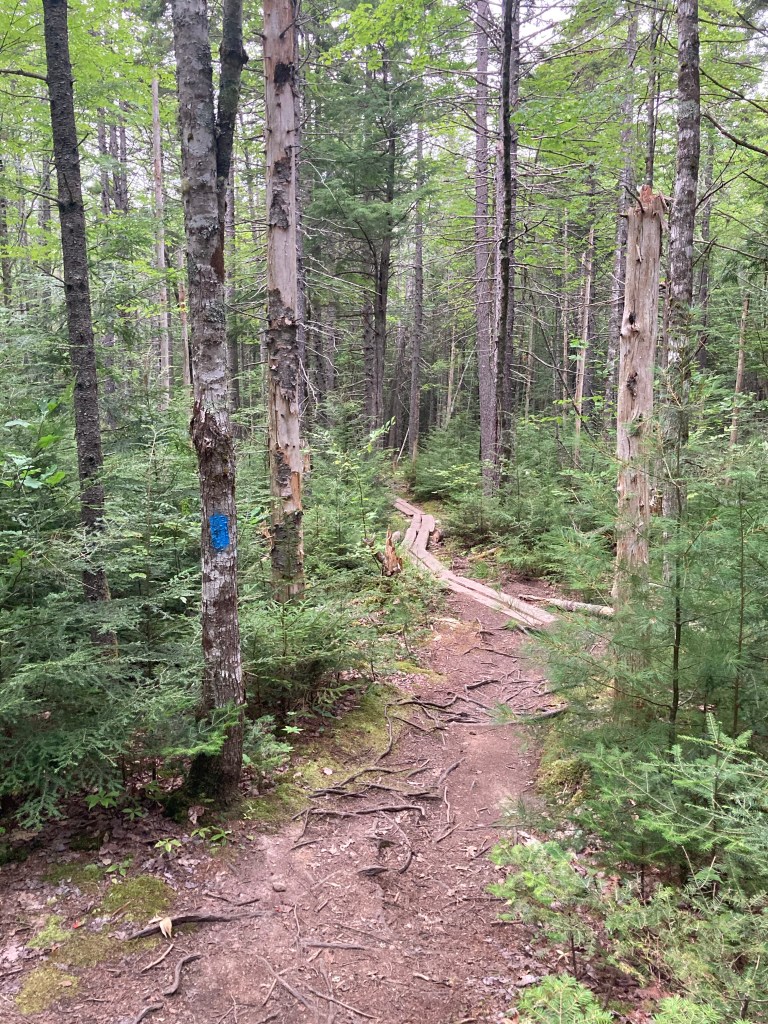
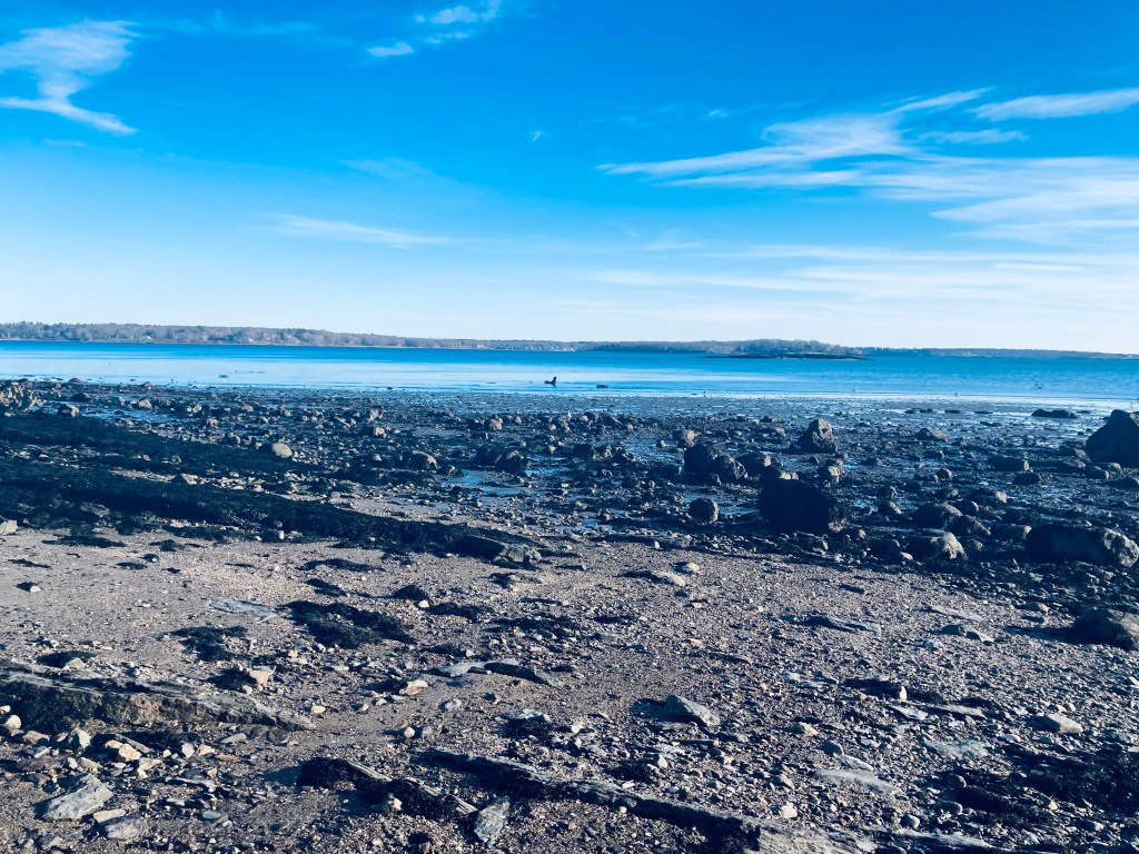
Mackworth Island, connected to the Falmouth mainland by a causeway off Andrews Avenue, is a State Park donated to the State of Maine in 1946 by Governor Percival Baxter for state public purposes and “as a sanctuary for wild beasts and birds.” The island, which also contains the Baxter School for the Deaf, is open daily 9 am to sunset. Parking is limited, so have a backup plan (the nearby Gilsland Farm Audobon is nice), or be prepared to wait. The visitor fee is currently $3 for Maine residents, $4 for non-Maine residents, and $1 for non-resident seniors and children 5-11 (Maine residents over 65 and children under 5 are free). An outhouse is available by the parking lot.

Mackworth Island, Falmouth, ME
Continue reading

Mount Will (Bethel, ME)

Icicles on the Nature Trail section of Mt. Will Trail, Bethel, ME

Mount Will (1,726 ft), which spans across the town lines of Newry and Bethel, Maine is a lesser-traveled peak, accessed through a loop trail, with a small parking area across the road from the Town of Bethel transfer station. This trail, marked with bright blue blazes, was developed by the Bethel Conservation Commission, and is maintained by the Town of Bethel. Detailed description can be found in Maine Hikes Off The Beaten Path or the AMC Maine Mountain Guide.

Androscoggin River Valley from North Ledges, Mt. Will Trail
Continue reading

Pleasant Hill Preserve (Scarborough, ME)

Eleanor’s Trail, Pleasant Hill Preserve, Scarborough, ME

Tucked between the Pleasant Hill neighborhood and the Rachel Carson National Wildlife Refuge, Scarborough’s Pleasant Hill Preserve is 135 acres of land, with over 1.5 miles of trails, held and maintained by the Scarborough Land Trust (SLT). No hunting or bicycles are allowed on the trails, dogs must be leashed, and the .25 mile Eleanor’s Trail is ADA accessible. The trailhead, at 270 Pleasant Hill Road in Scarborough, has year-round parking and a map kiosk.

Swallow Barn, and intersection with Monty’s Trail, Pleasant Hill Preserve, Scarborough, ME
Continue reading

Black Cat Mountain (Poland, ME)

Access road to the summit of Black Cat Mountain, Poland, Maine.

This easy mountain hike, actually more of a road walk to a hilltop where is a cell tower, made for a simple First Day 2021 winter stroll. Black Cat Mountain (820 ft) in Poland, Maine (not to be confused with the larger Black Cat Mountain in Baxter State Park), is accessible from North Raymond Road, where a small gated road marked with yellow cell tower signs and the number 72 has limited parking (with overflow on the road’s shoulder).

Afternoon light through the trees, road to Black Cat Mountain, Poland, ME.
Continue reading

Libby River Farm Preserve Trails (Scarborough, ME)

Access Trail, Libby River Farm Preserve, Scarborough Land Trust

Close to Prouts Neck and Scarborough Beach, the 75-acre Libby River Farm Preserve, tucked between Camp Ketcha and the Libby River, has about a mile of trails to explore. While well-attended, it is not as crowded as Ferry Beach and Scarborough Beach, and can be a good option if these places are busy.

Libby River Farm Preserve, owned and maintained by the Scarborough Land Trust, with a small parking area at 320 Black Point Road provided by Camp Ketcha, is open year-round for hiking, snowshoeing, and cross-country skiing. Dogs must be leashed, and bow-hunting (with Scarborough Land Trust permission) is allowed, so blaze orange is always a good fall idea.

Shrubland, Libby River Farm Preserve, Scarborough Land Trust
Continue reading

Celia and Jackson Ponds (Baxter State Park)

View across Kidney Pond, Baxter State Park

Having completed two strenuous hiking days in the northern part of Baxter State Park, I wanted to explore an easier path on my long, scenic way out through the Togue Pond Gate. Celia and Jackson Ponds, reached in that order, are accessed from the Kidney Pond campground day-use trailhead via a 3.2 mile (1.5 to 2 hours) out-and-back hike using the Sentinel Connector Trail, and Celia and Jackson Ponds Trail. I found this hike using Falcon Guides’ Hiking Maine’s Baxter State Park.

The pleasant smell of woodsmoke from the campground quickly gave way to that of pine, and the path has a definite enchanted woods feel, with soft, greenish light cast on the moss surrounding the trail. Shortly after the trail’s beginning, a large boulder on the left is whimsically marked “Kidney Stone – do not remove.” Kidney Pond can be seen through the trees, and then a small side trail to the shore provides excellent views of Katahdin to the west.

Giant boulder, Celia and Jackson Ponds Trail, Baxter State Park
Continue reading

Burnt Mountain (Baxter State Park)

Trail to Burnt Mountain summit, Baxter State Park, Maine

You will not find many mountain hikes in Baxter State Park marked as anything other than “difficult” or “strenuous,” but Burnt Mountain (1,810 ft) is a pleasant, gradual woods walk of about 2.6 miles that took me under an hour, with fewer roots and rocks than most other hikes nearby. The best description and map I found was in Hiking Maine’s Baxter State Park. Burnt Mountain Trail’s out-and-back hike begins at the Burnt Mountain Picnic Site. This remote trailhead, which has a picnic table and a toilet, is along the park’s Tote Road, in the northwest corner of the park, close to the Scientific Forest Management Area.

Changing leaves in the light of the opening after the summit, Burnt Mountain, Baxter State Park
Continue reading

South Branch Falls (Baxter State Park)

South Branch Falls, Baxter State Park

South Branch Falls is a short (about one mile out/back, less than an hour) waterfall hike, close to Baxter State Park’s South Branch Campground, in the northern part of the park, accessible from the Matagamon Gate. This family-friendly hike explores a fast-running section of the South Branch Ponds Brook. Full description, map and photos can be found in Falcon Guides’ Hiking Maine’s Baxter State Park.

South Branch Falls, Baxter State Park
Continue reading

Smalls Falls

Smalls Falls, Franklin County, Maine

Smalls Falls is a part waterfall hike, part scenic rest area, located along Route 4 in Franklin County, Maine. Plenty of parking, charcoal grills, toilet facilities, and picnic tables along the river make this an ideal place to stop for a picnic lunch, walk around, and even get in the falls and pools to cool off in the Rangeley area.

Smalls Falls, Franklin County, Maine
Continue reading

Tunk Mountain (T10 SD)

Plank bridges on Tunk Mountain trail

Located between the blueberry fields of Cherryfield and the Downeast coast, Tunk Mountain (1,157 feet) is part of the Donnell Pond Public Lands, managed by Maine’s Bureau of Parks and Lands (BPL), with the upper summit area on land owned by The Nature Conservancy (trail map). Parking for this moderate hike (about 3.9 miles out and back) is on the north side of the Blackwoods Scenic Byway (ME-182) between Sullivan and Cherryfield, consisting of a large lot, a pit toilet, and an information kiosk. This lot does fill up quickly, however, on weekends.

Boulders and caves, Tunk Mountain trail
Continue reading